Satellite parcel monitoring
Your land, watched.
Every time the satellite passes.
We check your parcel against fresh satellite imagery the moment it's published — and a trained human reviewer writes you a plain-English report. You pay only when there's something real to report.

The problem
You can't visit. You won't notice. Until it's too late.
Most land investors own parcels they haven't physically visited in months — or years. That's a costly blind spot.
- Encroachment, illegal dumping, and boundary incursion can go unnoticed for years on remote parcels
- By the time a boundary dispute is discovered, legal costs routinely exceed the value of the land itself
- Google Earth checks are inconsistent — most investors forget, and when they do check, they don't know which dates to compare
- Automated AI tools generate false alarms that erode trust — and miss context that a trained human catches immediately
"I bought 40 acres in East Texas as a long-term hold. Didn't visit for eight months. When I finally did, someone had cleared two acres of timber from the western corner. I had no idea when it happened or who did it."
— Land investor, BiggerPockets forum
How it works
Four steps, then you wait — we watch.
Step 01
Submit your parcel
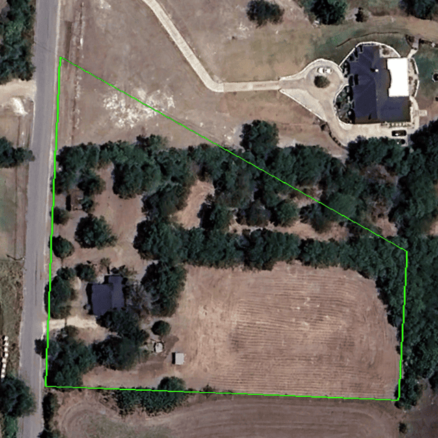
Give us an address, APN, or coordinates. We locate and map your exact parcel boundary — no GIS expertise required.
Step 02
We monitor continuously
We track satellite imagery update schedules for your area. The moment new, cloud-free imagery is published, we queue your parcel for review.
Step 03
A human reviews the images
A trained analyst compares the latest imagery against your baseline — looking for structures, clearing, tracks, or boundary changes. No algorithms, no false alarms.
Step 04
You get a clear report
A plain-English email with annotated before/after images and a plain recommendation. You are only billed if a report is sent — never for a quiet month.
Our difference
Not AI. Not automated.
Deliberately human.
Every competitor in this space is rushing to automate. We went the other direction — on purpose. Automated change detection generates false alarms that waste your time and erode your trust in the service. A trained human reviewing your parcel catches context, pattern, and nuance that no algorithm reliably does yet.
We may eventually add AI as an internal screening tool. But a human will always sign off on every report that reaches your inbox.
| Feature | Land Change Alerts | Automated tools |
|---|---|---|
| Report reviewer | ✓ Trained human | Algorithm only |
| False alarm rate | ✓ Very low | High (cloud, shadow) |
| Charge when nothing changes | ✓ Never | Monthly flat fee |
| Context & interpretation | ✓ Included | ✗ Not possible |
| Missed change credit | ✓ Guaranteed | ✗ No recourse |
Pricing
Buy reports. Not subscriptions.
Purchase a balance of monitoring credits. One credit = one human-verified report in your inbox. Credits never expire. Cloud cover never costs you.
Credits never expire
Your balance carries forward indefinitely. Buy when it suits you, use them as reports are delivered.
Cloud cover? No charge
If satellite imagery is obscured by weather, we wait. Credits are only deducted when a clear, usable report is delivered.
Pay for the work, not the wait
Larger parcels require more analysis. Cost scales with acreage — not with a flat fee that ignores the actual work involved.
Credits per report by parcel size
| Parcel size | Credits used |
|---|---|
| Under 10 acres | 1 credit |
| 10 – 50 acres | 2 credits |
| 50 – 200 acres | 3 credits |
| 200 – 500 acres | 4 credits |
| 500 acres and above | 5 credits |
Not sure how many acres your parcel is? Send us the address — we'll look it up and tell you exactly what a report will cost before you buy anything.
Credit bundles
| Bundle | Credits | Price | Per credit |
|---|---|---|---|
| Starter | 5 | $59 | $11.80 |
| Standard | 12 | $119 | $9.92 |
| Investor ★ | 25 | $199 | $7.96 |
| Portfolio | 60 | $399 | $6.65 |
★ Most popular. A 25-acre parcel with the Investor bundle = up to 12 full reports. Monitoring multiple parcels? Credits work across all of them.
Example
You own a 30-acre parcel in Texas. That's 2 credits per report. Buy the Standard bundle (12 credits, $119) and you have six full human-verified reports — enough for over a year of typical monitoring. Unused credits roll forward forever.
Start free auditFirst report is free · No credit card required to start · Questions? See the FAQ →
Who watches with us
Absentee land investors
Owners of raw land held as long-term speculation who live far from their parcels and can't visit regularly.
Small property developers
Developers waiting on planning permission who need to monitor adjacent plots for activity that affects their project.
Rural landlords
Owners of storage sites, agricultural land, or commercial plots concerned about fly-tipping, encampments, and access.
Estate executors
Individuals managing inherited land in probate who need documentation of the parcel's condition over time.
Conservation land holders
Owners of conservation easements or protected land who must document and prove no development has occurred.
Land flippers
Active investors doing due diligence on parcels they are considering purchasing — verifying current use and condition.
Sample report
This is what lands in your inbox.
A real report, stripped of client details. Plain English, annotated images, clear recommendation.
October 2024
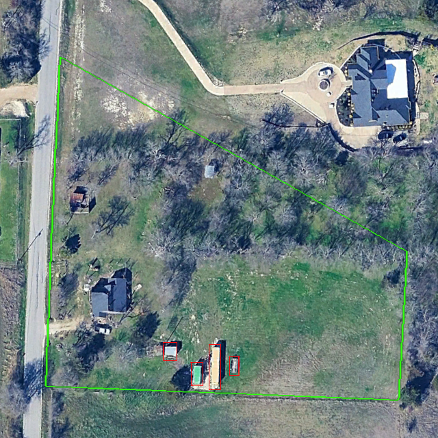 November 2024
Finding
Four new structures approximately 13×10 ft (shed), 20×8 ft (shipping container), 40×8 ft (shipping container), 15×5 ft (shed or building materials) have appeared in the south-central area of the parcel between the October and November imagery. Recommended action: contact county assessor to verify permit status and inspect parcel if access is possible.
No other changes noted
Northern, eastern and western boundaries show no evidence of encroachment. Vegetation cover consistent with previous imagery. No evidence of dumping or clearing elsewhere on the parcel.
FAQ
Honest answers to hard questions.
The person watching your land
A real person signs every report.
We are not a faceless platform. Every report that reaches your inbox has been reviewed and signed by the analyst who knows your parcel best.

Yuri K
Founder · Lead Analyst
I was born in the East and grew up in the West, so I've never really fit neatly into one box - and that's probably why Land Change Alerts exists. I live in South Africa now with my wife and two kids. They're the reason I care about building something honest. I want my children to see that you can run a business without hype, without pretending AI does everything, and without charging people for nothing.
I got into satellite imagery through real estate - I needed to monitor parcels I couldn't physically visit, and the tools out there were either overpriced, over-automated, or plain useless. Before this, I built a couple of businesses. Some worked, some taught me hard lessons, all of them shaped how I think about building something people will actually pay for. When I'm not reviewing parcels or running the company, I'm a volunteer firefighter and I make music. Both keep me grounded. Both are about paying attention, staying calm under pressure, and showing up - same things I try to bring to every report that lands in your inbox.
Specialises in: agricultural land, rural, boundary encroachment, timber clearing
Every report is signed by the analyst who reviewed it — so you always know exactly who is responsible for what lands in your inbox. yuri@landchangealerts.com →
Free audit
Let a real person
watch your land for 30 days.
No credit card. No commitment. We set up monitoring for your parcel, and if new imagery is available during your audit, you receive your first report completely free. If you don't find it useful, you owe nothing and we part as friends.
- First report completely free
- No credit card at signup
- Human reviewer assigned within 24 hours
- You’ll hear from us within 24h. We’ll confirm your parcel details and set you up for monitoring
- The first report arrives only when new imagery is available. We’ll advise on expected cadence
- Cancel any time, no questions asked
- Works for any land parcel, any size
Start your free audit